 In early 2008 we were commissioned, along with Black Sheep Countryside Management, by the North Wessex Downs Area of Outstanding Natural Beauty (AONB) to produce an Arable Strategy that included a target map to highlight areas of high potential for farmland birds, mammals and arable flora (see Table 1) within the AONB. This was to help AONB staff promote management practices that enhance and extend areas of high arable biodiversity and identify where other management priorities might be in conflict with promoting a diverse arable environment, for instance expanding chalk downland through arable reversion.
Agri-environment funds are often prioritised and allocated using a targeted approach, usually based on recorded sightings of wildlife of conservation concern, with those of declining farmland bird species given particular importance. One drawback to this approach is that the distribution of other fauna and flora is not considered. Another is that using the known local distribution of flora and fauna to construct these target maps means that land where no surveys have been undertaken or where the required biodiversity information is not easily available may be excluded.
Our approach used information about the location of arable plants and mammals, in addition to farmland birds, to overcome these drawbacks and identify arable land with the highest density of arable plants, mammals and farmland birds in the AONB. We also identified areas with few records but with similar elevation, aspect and soil types and included these as places where the physical conditions made it likely that the arable plants, birds and mammals we were interested in could be found. Further refinement to the map included only selecting land that historically had been either arable or open land, using English Heritage’s Historic Landscape Character (HLC) areas. The result was a target area that covered a third of the North Wessex Downs.
Table 1: Species used in the construction of this target
Arable plants
Broad-leaved spurge, corn buttercup, corn chamomile, corn cleavers, corn marigold, corn parsley, corn spurrey, corncockle, cornfield knotgrass, cornflower, cut-leaved dead-nettle, dense-flowered fumitory, dwarf spurge, few-flowered fumitory, field gromwell, field madder, field woundwort, grey field-speedwell, henbit dead-nettle, knotted hedge-parsley, mousetail, narrow-fruited cornsalad, prickly poppy, red hemp-nettle, rough poppy, round-leaved fluellen, sharp-leaved fluellen, shepherd’s needle, slender tare, small toadflax, spreading hedge-parsley, Venus’ looking-glass, wild candytuft and yellow vetchling.
Records were provided by the Thames Valley Environmental Record Centre, Wiltshire and Swindon Biological Records Centre, Hampshire Biodiversity Information Centre, Northmoor Trust, Plantlife and Simon Smart. The dates of recording were from 1954 to 2006, with the majority (70%+) collected since 1995; we only used records whose location was plotted to the nearest 100 metres.
|
Farmland birds
Corn bunting, grey partridge, lapwing, stone-curlew, tree sparrow, turtle dove and yellow wagtail.
Records were provided by through the Bird Conservation Targeting Project with the aid of Natural England and the Royal Society for the Protection of Birds. The dates of recording were from 2000 to 2006, with data on individual species location supplied to the nearest kilometre.
|
Farmland mammals
Brown hare and harvest mice.
Records were provided by the Thames Valley Environmental Record Centre, Wiltshire and Swindon Biological Records Centre and Hampshire Biodiversity Information Centre. The dates of recording were from 1968 to 2006, with the majority (50%+) collected since 1980; we only used records whose location was plotted to the nearest 100 metres. |
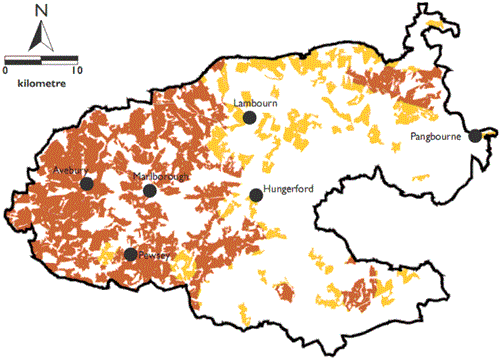
Figure 1: Using our Arable Strategy target map to identify areas where further survey work is needed

We examined two applications of our target map. The first was to identify areas where further survey work for arable flora and fauna is needed by selecting farmland where there were few records of the arable flora and fauna, but which had similar conditions to areas with high densities of these species (see Figure 1). The other application was to identify areas with conflicting management priorities, for example the promotion of chalk downland through reversion to grassland rather than the promotion of extensive arable farming.
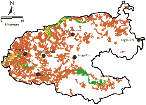
We compared our target area with the AONB’s Chalk Grassland Strategy, compiled by the Wilts and Swindon Biological Records Centre, which identifies potential areas for targeted expansion of chalk grassland to link existing chalk grassland sites (see Figure 2). Just over 40% of the area selected by the Chalk Grassland Strategy was within our target area for arable biodiversity, identifying conflicts between the two strategies.
We feel that where these two models overlap, the biodiverse arable area – particularly with regard to rare arable flora – should be maintained or enhanced, avoiding reversion to grass. If the priority is to revert to grassland, a thorough survey for arable biodiversity should be undertaken to ensure that arable species will not be lost. It should be possible to maintain a diversity of habitats that includes species-rich semi-natural grassland alongside extensively-managed arable farmland. The method we devised is applicable throughout the country, allowing for targeting that is more representative of arable flora and fauna in general than some of the current approaches.
Figure 2: Our Arable Strategy target map overlaid onto Chalk Grassland Strategy map
